The south end of India
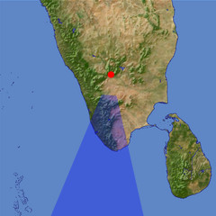
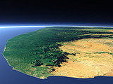
At the southern end of the Indian Peninsula the mountains of the Western Ghats separate the dry east coast of the peninsula from the humid Malabar Coast on the west side. The Anai Mudi (2695m) in the Cardamom Hills, the highest peak in southern India can be seen in the foreground. The humid west coast and mountain parts are famous for the spices grown there.
| Ansicht: | The south end of India |
| Position: | Lon 77.318° Lat 11.583° |
| Höhe: | 59 km |
| Richtung: | 185° |
| Kamerawinkel: | 36° |
| Bewertung: | 2.6 |
Umgebungskarte: Optisch Topographie

Start •
Impressum •
Nutzungsbedingungen •
Sitemap •
Bilder:
Liste
/
Karte /
Galerie •

imagico.de • blog.imagico.de • services.imagico.de • maps.imagico.de • earth.imagico.de • photolog.imagico.de
imagico.de • blog.imagico.de • services.imagico.de • maps.imagico.de • earth.imagico.de • photolog.imagico.de


Kommentare:
noch keine Kommentare.
Durch das Abschicken Ihres Kommentars stimmen Sie der Datenschutzrichtlinie zu und erlauben, dass die eingegebenen Informationen (mit Ausnahme der eMail-Adresse) in diesem Blog veröffentlicht werden.