Views of the Earth

artificial images of our real planet
The Adrar Plateau location map

The Adrar Plateau

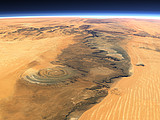
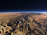
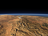
The Adrar Plateau is one of the most articulated relief features in the otherwise flat desert of Mauritania. In the background the characteristic form of the Richat Structure can be seen.

View: The Adrar Plateau
Location: Lon -14.027°
Lat 19.898°
Altitude: 39 km
Direction: 62°
Camera Angle: 44°
User Rating: 2.5
Location Map:    Visible Topography
The Adrar Plateau location map
The Adrar Plateau

Related Views:

The Richat Structure
Atlas Mountains
Atlas Mountains 2
Canary Islands 3

Visitor comments:

no comments yet.

Leave a comment
You have to enable Javascript to be able to write comments.
human verification Please enter the code you can see in the image on the left to verify you are a human and not a spamming script.
* * Required field
Information about you
*
will not be made public
will be displayed with your posting
Your comment (no HTML)

*

If you want to send a private message to the author of this website you can do so via Email.

The comments will be reviewed before they are added to the site. So you might need to wait some time until your entry turns up.

Please note this comment function is intended for commenting on the text and images, not for discussing political or religious views. Comments with no relation to the content of this site will not be approved.

By submitting your comment you agree to the privacy policy and agree to the information you provide (except for the email address) to be published on this website.

  
Design and Content Copyright 2023 by Christoph Hormann
last updated Sun, 16 Jul 2023 20:38