The Maoke Mountains
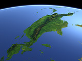
The Maoke Mountain range is the highest mountain range of New Guinea dividing the island from east to west. Its highest peak, the Puncak Jaya (4884m) lies in the middle of this view and is one of the few glaciered peaks in equatorial regions on earth.
| View: | The Maoke Mountains |
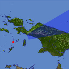
| Location: | Lon 131.947° Lat -6.054° |
| Altitude: | 149 km |
| Direction: | 70° |
| Camera Angle: | 20° |
| User Rating: | 2.5 |
Location Map: Visible Topography

Home •
Impressum •
Terms •
Sitemap •
Browse:
list
/
map /
gallery •

imagico.de • blog.imagico.de • services.imagico.de • maps.imagico.de • earth.imagico.de • photolog.imagico.de
imagico.de • blog.imagico.de • services.imagico.de • maps.imagico.de • earth.imagico.de • photolog.imagico.de


Visitor comments:
but next time try and add more info into it, or else it's good.
oh yeah, you will need some close ups on the images as well. so yeah.
By submitting your comment you agree to the privacy policy and agree to the information you provide (except for the email address) to be published on this website.