Related Views:
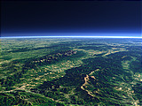

The High Tatras form the northmost part of the Carpathian Mountains. It is a very small yet high mountain range at the border between Poland and Slovakia with the highest peaks above 2500m.
| View: | The High Tatras |
| Location: | Lon 20.863° Lat 49.156° |
| Altitude: | 13 km |
| Direction: | 276° |
| Camera Angle: | 40° |
| User Rating: | 2.6 |

Visitor comments:
Beautiful photo!
but actually your caption is wrong... on the picture there's the whole massive of Tatra Mountains, shown from south east. The first small range going into the view and slightly towards right is called Bielskie Tatras, then there is the whole High Tatras and behind it the Western Tatras.
2500m is the height of Rysy Peak - precisely it's 1m less and the highest is Gerlach - 2650m.
I think it might be helpful to have a look at a map to understand :)
Thanks!
By submitting your comment you agree to the privacy policy and agree to the information you provide (except for the email address) to be published on this website.