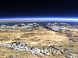
The Kali Gandaki Gorge from north
Between the Annapurna massif on the left and the Dhaulagiri on the right the Kali Gandaki river has cut a deep gorge into the main Himalayan mountain ridge. This gorge marks one of the lowest altitude crossings in the Himalayas with an elevation of just 4660m at a pass near the foreground end of this view. The upper part of the valley froms the region and former independent kingdom of Mustang which is today part of Nepal.
| View: | The Kali Gandaki Gorge from north |
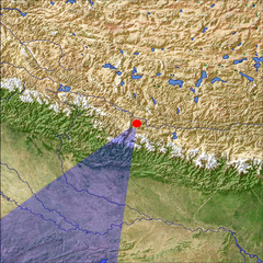
| Location: | Lon 84.13° Lat 29.367° |
| Altitude: | 13 km |
| Direction: | 210° |
| Camera Angle: | 46° |
| User Rating: | - |
Location Map: Visible Topography
Home •
Impressum •
Terms •
Sitemap •
Browse:
list
/
map /
gallery •

imagico.de • blog.imagico.de • services.imagico.de • maps.imagico.de • earth.imagico.de • photolog.imagico.de
imagico.de • blog.imagico.de • services.imagico.de • maps.imagico.de • earth.imagico.de • photolog.imagico.de


Visitor comments:
no comments yet.
By submitting your comment you agree to the privacy policy and agree to the information you provide (except for the email address) to be published on this website.