Views of the Earth

artificial images of our real planet
Kongur Tagh and Muztagh Ata location map

Kongur Tagh and Muztagh Ata

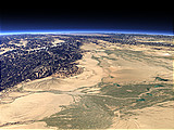
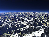
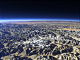
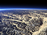
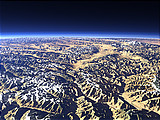
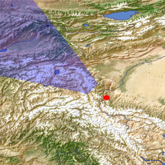
The Kongur Tagh and Muztagh Ata Mountains are located in the far west of China southwest of the Taklamakan Desert that is visible at the right side of this view. Muztagh Ata in the center of the image has an altitude of 7546m and Kongur Tagh more to the right is 7649m high. Behind the mountains the Pamir Plateau with the Karakul Lake can be seen.

View: Kongur Tagh and Muztagh Ata
Location: Lon 76.439°
Lat 37.454°
Altitude: 59 km
Direction: 307°
Camera Angle: 45°
User Rating: 1.8
Location Map:    Visible Topography
Kongur Tagh and Muztagh Ata location map
Kongur Tagh and Muztagh Ata

Related Views:

The Kongur Shan Mountains and the Eastern Taklamakan
The Fedchenko Glacier
The northern Pamir and the Fedchenko Glacier
The Pamir Plateau
The Khunjerab Pass

Visitor comments:

no comments yet.

Leave a comment
You have to enable Javascript to be able to write comments.
human verification Please enter the code you can see in the image on the left to verify you are a human and not a spamming script.
* * Required field
Information about you
*
will not be made public
will be displayed with your posting
Your comment (no HTML)

*

If you want to send a private message to the author of this website you can do so via Email.

The comments will be reviewed before they are added to the site. So you might need to wait some time until your entry turns up.

Please note this comment function is intended for commenting on the text and images, not for discussing political or religious views. Comments with no relation to the content of this site will not be approved.

By submitting your comment you agree to the privacy policy and agree to the information you provide (except for the email address) to be published on this website.

  
Design and Content Copyright 2023 by Christoph Hormann
last updated Sun, 16 Jul 2023 20:38