Views of the Earth

artificial images of our real planet
The Kali Gandaki Gorge location map

The Kali Gandaki Gorge

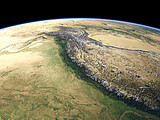
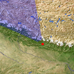
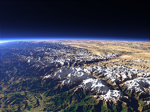
The Kali Gandaki Gorge cuts through the main ridge of the Himalaya Mountains between the Annapurna (8091m) and the Dhaulagiri (8167m) Mountains. This view shows the valley from the east coming from the Tibet Plateau on the right, passing between Annapurna in the foreground and Dhaulagiri in the background until it reaches the plains of southern Nepal on the far left. The Gandaki River later joins the Ganges in northern India.

View: The Kali Gandaki Gorge
Location: Lon 84.501°
Lat 27.849°
Altitude: 39 km
Direction: 324°
Camera Angle: 53°
User Rating: 2.6
Location Map:    Visible Topography
The Kali Gandaki Gorge location map
The Kali Gandaki Gorge

Related Views:

The Himalaya
The Himalaya in Nepal
The Indus River 1

Visitor comments:

no comments yet.

Leave a comment
You have to enable Javascript to be able to write comments.
human verification Please enter the code you can see in the image on the left to verify you are a human and not a spamming script.
* * Required field
Information about you
*
will not be made public
will be displayed with your posting
Your comment (no HTML)

*

If you want to send a private message to the author of this website you can do so via Email.

The comments will be reviewed before they are added to the site. So you might need to wait some time until your entry turns up.

Please note this comment function is intended for commenting on the text and images, not for discussing political or religious views. Comments with no relation to the content of this site will not be approved.

By submitting your comment you agree to the privacy policy and agree to the information you provide (except for the email address) to be published on this website.

  
Design and Content Copyright 2023 by Christoph Hormann
last updated Sun, 16 Jul 2023 20:38