Views of the Earth

artificial images of our real planet
The Algarve and Cape of St.Vincent location map

The Algarve and Cape of St.Vincent

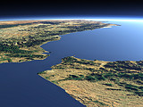
The south western end of Europe is marked by the Cape of St.Vincent in southern Portugal. The Algarve coast east of the cape is popular among tourists especially in the summer.

View: The Algarve and Cape of St.Vincent
Location: Lon -9.875°
Lat 36.207°
Altitude: 59 km
Direction: 50°
Camera Angle: 36°
User Rating: 2.7
Location Map:    Visible Topography
The Algarve and Cape of St.Vincent location map
The Algarve and Cape of St.Vincent

Related Views:

The Strait of Gibraltar
The Spanish Sierra Nevada

Visitor comments:

by Shahriyar Ismayilzade posted on Sat Jan 24 2009 22:43:24
Wonderful.....! From Cape of St. Vincent towards Cape of Good Hope (due to Prince Henry the Navigator)
Leave a comment
You have to enable Javascript to be able to write comments.
human verification Please enter the code you can see in the image on the left to verify you are a human and not a spamming script.
* * Required field
Information about you
*
will not be made public
will be displayed with your posting
Your comment (no HTML)

*

If you want to send a private message to the author of this website you can do so via Email.

The comments will be reviewed before they are added to the site. So you might need to wait some time until your entry turns up.

Please note this comment function is intended for commenting on the text and images, not for discussing political or religious views. Comments with no relation to the content of this site will not be approved.

By submitting your comment you agree to the privacy policy and agree to the information you provide (except for the email address) to be published on this website.

  
Design and Content Copyright 2023 by Christoph Hormann
last updated Sun, 16 Jul 2023 20:38