Related Views:
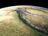
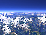

The eastern end of the Himalaya Mountains is marked by the Namcha Barwa (7782m) in the center of this view. North of it the Yarlung Tsangpo river crosses the main mountain ridge in a deep canyon to later become the Bramaputra. In the background the Himalaya continues between the Tibetan Plateau on the right and the plains of northern India on the far left.
| View: | The Eastern Himalaya |
| Location: | Lon 97.364° Lat 30.1° |
| Altitude: | 59 km |
| Direction: | 253° |
| Camera Angle: | 45° |
| User Rating: | 2.5 |

Visitor comments:
no comments yet.
By submitting your comment you agree to the privacy policy and agree to the information you provide (except for the email address) to be published on this website.