Views of the Earth

artificial images of our real planet
The Tsangpo Gorge location map

The Tsangpo Gorge

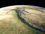
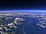
The Tsangpo Gorge is the canyon where the Yarlung Tsangpo coming from the Tibetan Plateau cuts through the ridge of the Himalaya Mountains. The altitude difference from the bottom of the valley to the peaks of the adjacent mountains (the Namcha Barwa on the left) is more than 5000m at a distance of just about 20km.

View: The Tsangpo Gorge
Location: Lon 95.424°
Lat 29.76°
Altitude: 13 km
Direction: 254°
Camera Angle: 50°
User Rating: 2.3
Location Map:    Visible Topography
The Tsangpo Gorge location map
The Tsangpo Gorge

Related Views:

The Himalaya
The Himalaya in Nepal
The Eastern Himalaya
Namcha Barwa and Gyala Peri
The Eastern Himalaya 2

Visitor comments:

by Gordon Wiltsie from United States posted on Sun Dec 2 2007 05:53:41
I photographed the Tsangpo Gorge in 1993 from the ground. This perspective is awesome.
by uday from India posted on Wed May 9 2007 09:11:38
Views are spellbound .. am presently reading a book called River Dog by Mark Shand who has travelled along the river Brahmapurtra and after reading about the gorge, really wanted to have a glimpse of it.. Thanks.
HomeAboutimagico.dephotolog.imagico.de • Browse: list / map / galleryRSS feed
Design and Content Copyright 2010 by Christoph Hormann
last updated Fri, 25 Jun 2010 17:40