Views of the Earth

artificial images of our real planet
The Great Rift Valley location map

The Great Rift Valley

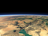
The Great African Rift Valley is a large breach in the crust of the earth where the African continent showly splits into two parts. Many lakes can be seen along the rift, among them the Lake Victoria, the largest lake of Africa.

View: The Great Rift Valley
Location: Lon 38.695°
Lat -17.822°
Altitude: 2829 km
Direction: 349°
Camera Angle: 30°
User Rating: 2.5
Location Map:    Visible Topography
The Great Rift Valley location map
The Great Rift Valley

Related Views:

Kenyan Rift Valley
The Afar Triangle

Visitor comments:

by jackie from United States posted on Wed Feb 25 2009 22:43:32
im really amazed this is weird im only in sixth grade but im in love with science we are doing this project on the great rift valley and this is really helpful thx.
by Miranda from United States posted on Tue Jan 6 2009 01:58:55
These pictures were amazing and very helpful! I am in eighth grade and I am studying diverging continental plates. We are doing a report on the geographical results of the plates, which is a rift valley. This provided an interesting view of the rift valley and a very awesome visual! Thanks a ton, Miranda <3
by Danny from Uganda posted on Thu Oct 9 2008 09:41:07
I am Scottish but I am helping to train teachers in Uganda. I have used this image with our students. They are amazed and thrilled to see there country from space. Many of our students live on the edge of the rift valley
Thank you
by cheekz from United States posted on Wed Apr 2 2008 18:48:02
omg this is like soo awsom to the real i love this picture
by Tashi from United States posted on Tue Dec 4 2007 02:48:29
i love this picture where did you get it.

showing 5 of 8 comments. Show all.

HomeAboutimagico.dephotolog.imagico.de • Browse: list / map / galleryRSS feed
Design and Content Copyright 2010 by Christoph Hormann
last updated Sat, 23 Jan 2010 19:24