Related Views:
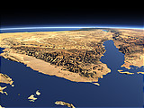
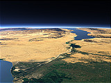
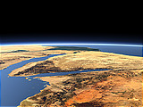
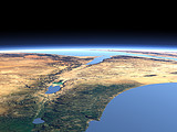

The Gulf of Aqaba is the eastern branch of the Red Sea at the northern end and is part of the East African rift system up to the Dead Sea further north. This view from the north shows the Wadi Araba connecting the Dead Sea with the Gulf. East of the Wadi the ancient Nabataean city of Petra can be found.
| View: | The Wadi Araba |
| Location: | Lon 35.761° Lat 31.281° |
| Altitude: | 19 km |
| Direction: | 202.5° |
| Camera Angle: | 42° |
| User Rating: | 2.4 |


Visitor comments:
Congratulations!
By submitting your comment you agree to the privacy policy and agree to the information you provide (except for the email address) to be published on this website.