Related Views:
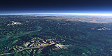

The Cascade Mountain range at the northern part of the US-American west coast contains several prominent mountains. On this view from bottom to top: Mount Jefferson (3199m), Mount Hood (3429m), Mount Adams (right, 3743 m), Mount St. Helens (left, 2550m) and Mount Rainier (4392m). Between them the Columbia River and in the background Puget Sound and southern Canada with Vancouver Island.
| View: | The Cascade Range |
| Location: | Lon -120.56° Lat 41.158° |
| Altitude: | 149 km |
| Direction: | 353° |
| Camera Angle: | 28° |
| User Rating: | 2.7 |


Visitor comments:
By submitting your comment you agree to the privacy policy and agree to the information you provide (except for the email address) to be published on this website.